
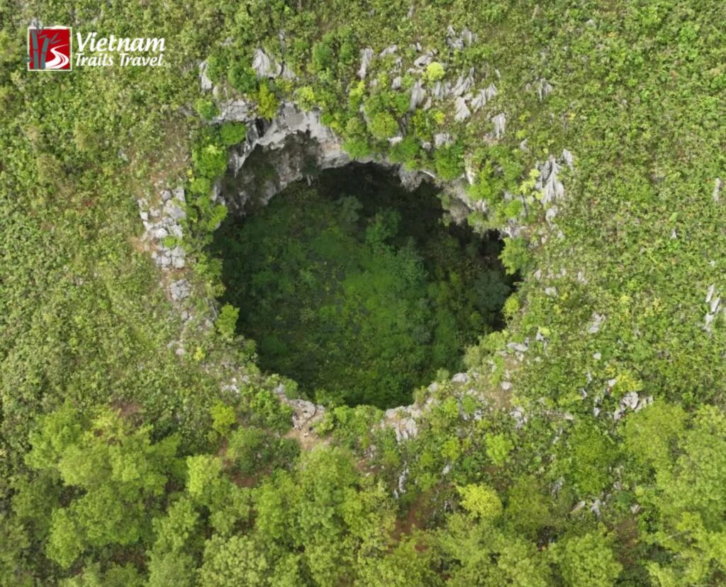
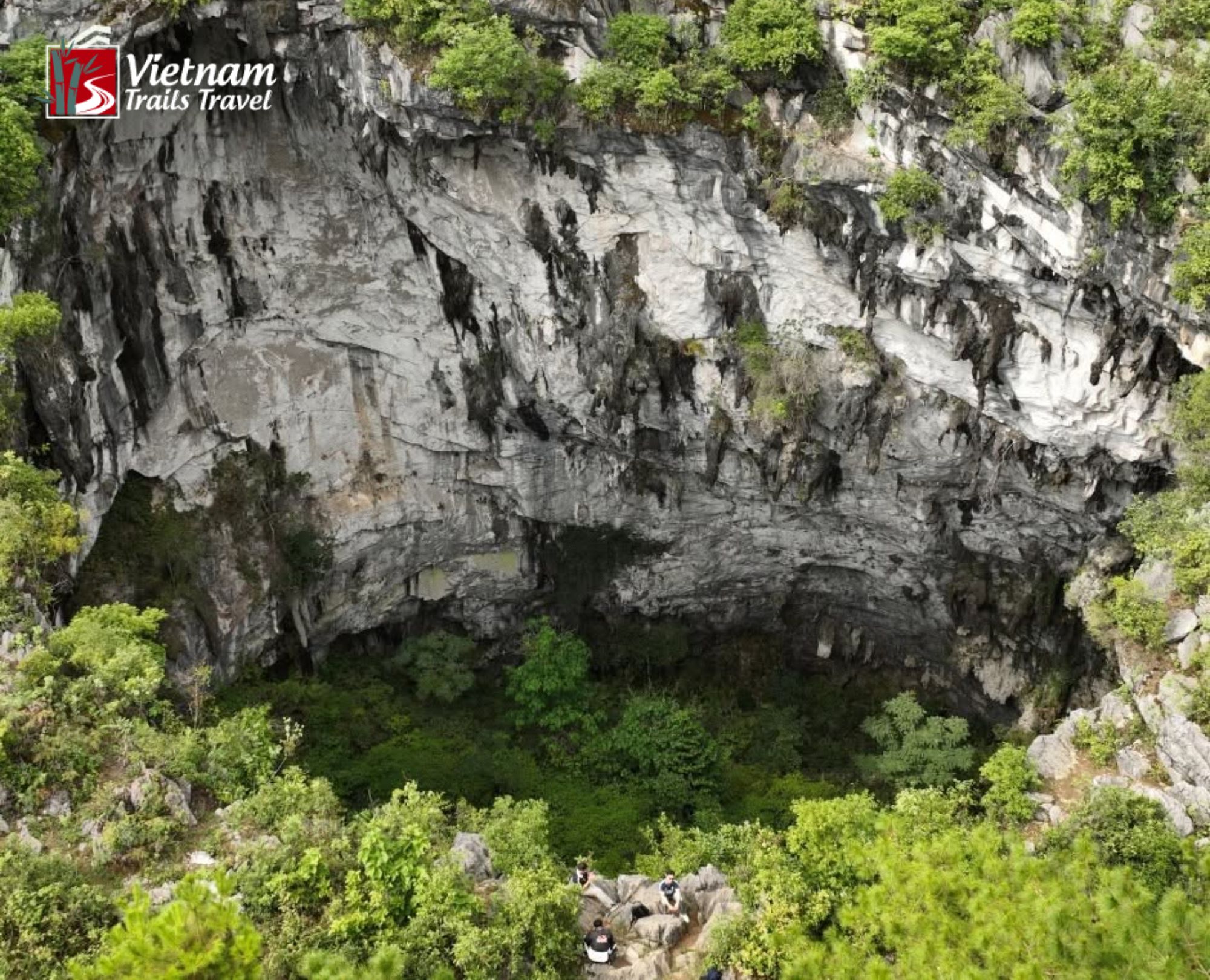
Meo Vac Sinkhole is a natural hole about 80 meters deep on a pine-covered hill, roughly 2 to 3 km from the district town in Ha Giang Province, at the northernmost edge of Vietnam.
Rope teams have reached its floor since the opening was found in 2021, and the site has still not been developed for tourism. Most visitors see the rim and the hillside with a driver and a guide, while the descent stays reserved for trained climbers.
1. Quick facts about Meo Vac Sinhole before you go
The table below gathers the figures that appear most often in news reports about the site.
| Detail | Information |
|---|---|
| Hamlet and commune | Tia Chi Dua hamlet, Giang Chu Phin commune |
| Distance from the district town | 2 to 3 km, depending on the report |
| Reported depth | About 80 m |
| Entrance spotted | 2021, on satellite maps and drone footage |
| Descent method | Fixed ropes on the rock face |
| Tourism status | Not developed, according to 2023 reports |
| Practical base | The district town |
| Suggested months | September to December |
The depth comes from a video report, the distance range from two different articles, and the tourism status from coverage dated 2023. Each figure should therefore be confirmed with the driver or operator before the visit.
2. What exactly is this hole in Ha Giang?
2.1 How it formed
The hole opens in limestone on the Dong Van Karst Plateau, a region recognized as a UNESCO Global Geopark. Karst terrain explains why this rocky plateau holds so many openings.
Rain drains directly into fractured limestone, and over thousands of years the water widens cracks into shafts and caverns. When the roof of a cavern becomes thin enough, the ground gives way and leaves an open drop with steep sides. Chinese geologists call the largest examples tiankeng, a term that translates roughly as heavenly pit.
Residents told the first visitors that they do not know when this particular hole formed, so no confirmed date or cause exists. Pine trees surround the rim, and villagers cut grass on the hillside above it for their cattle. The 2023 reports show no developed viewing area at the edge.
2.2 Why it has so many names
In Vietnamese, the site is called Hố sụt Mèo Vạc, a plain description of a collapsed hole in the district. Online communities added more dramatic names, among them Death Sinkhole and Sky Well. The Vietnamese form of the second name, Giếng trời Hà Giang, carries the same meaning.
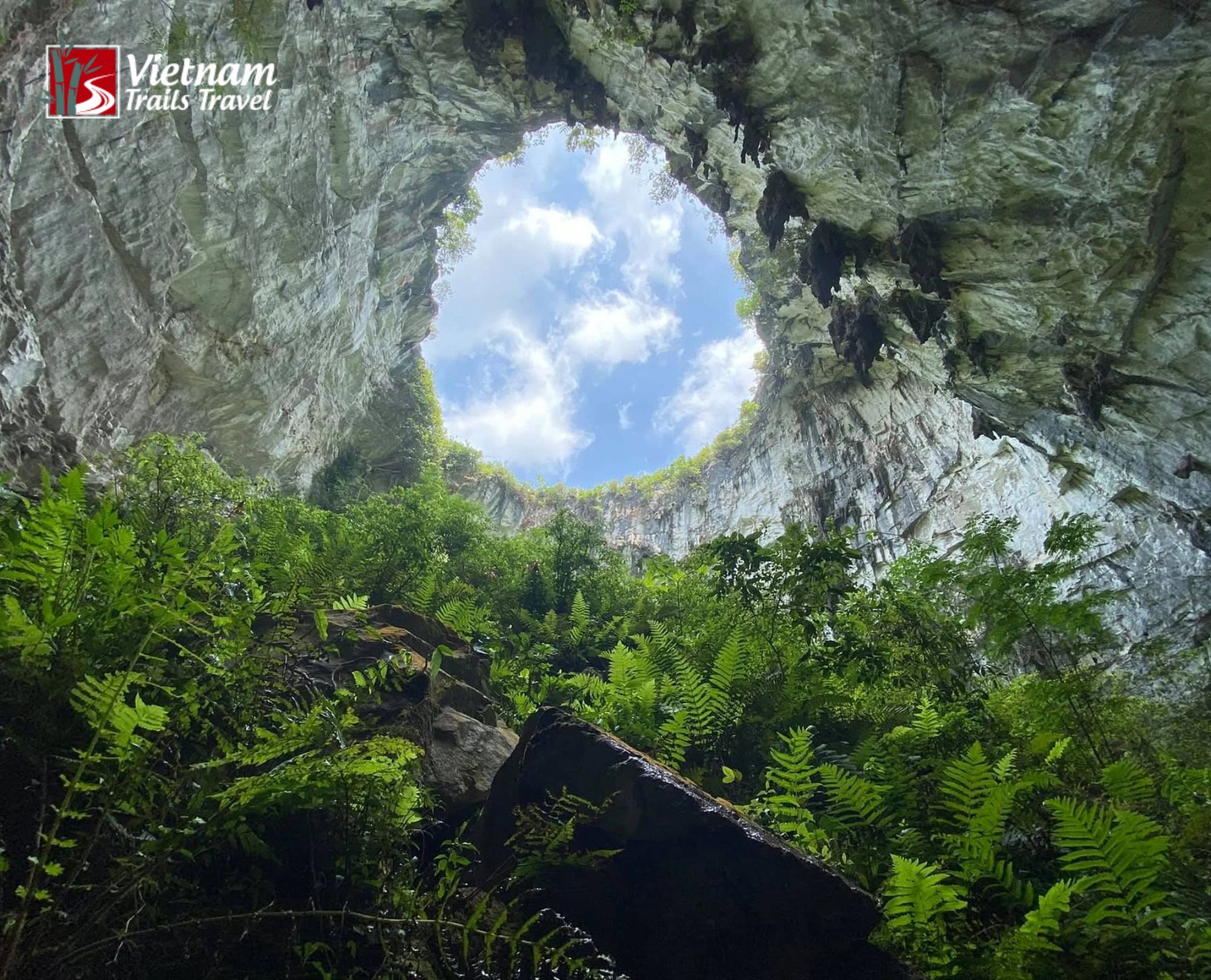
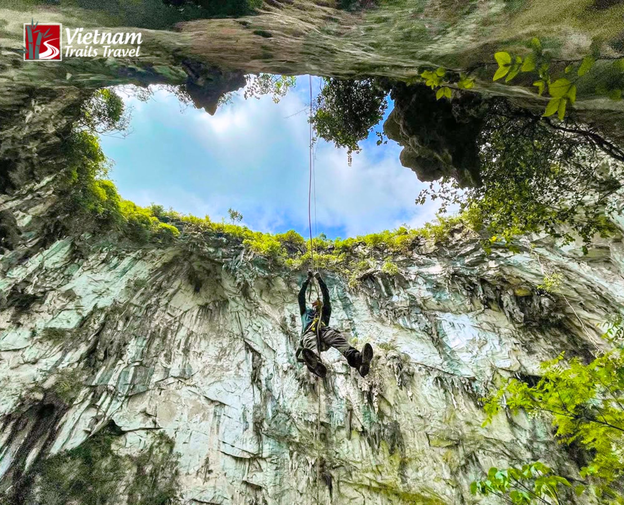
The Sky Well name comes from the view upward. At the base, as Hai described it, the sky appears no larger than the opening itself, a small disc framed by tree crowns and rock. None of the reports reviewed ties the Death label to a recorded accident at this hole, so the name appears to reflect the drama of the drop rather than a known history.
Read more: Ha Giang Loop Adventure: A Complete Travel Guide 2026
3. How the hole was found
3.1 2021: a drone spots the entrance
In 2021, Giap Van Hai, then 32 and working as a guide in the highlands, found the entrance while studying satellite maps with colleagues and flying a drone over the hills. By his own account, he had spent years in the area without seeing any sign of an opening there, and the team was not searching for one that day.
Two bloggers, Hoang Nam and Nang Cao Nguyen, took part in the survey and helped spread the find. Photos in the first post drew quick attention, and many viewers assumed the images came from Quang Binh, the area famous for its caves. Surprise followed when people learned the hole sits in the far north.
3.2 2022: a video shows the way down
In October 2022, VnExpress International published a video that follows Hai, the tour guide behind the discovery, down a sheer and rugged cliff. Two local men lead the way until he reaches the bottom of the drop. The video gives the depth as 80 meters, and that is the figure used in this article.
3.3 What the media said
Dan Tri, republished by kienthuc.net.vn, carried Hai’s account about two years after the find, including his description of the entrance and the descent. MIA.vn described a destination found only recently, close enough to the district town to draw young visitors once the first photos appeared. Tap Chi Cong Thuong reported that backpackers and long-distance riders took notice within a few years of the discovery and that the community gave the site several names.
4. What it looks like inside
4.1 Going down the rock face
From the rim, the opening looks like a thicket. At the mouth, a visitor sees tree crowns and no visible floor, which makes the depth hard to judge by eye. Hai’s team rigged safety ropes and worked down a rock wall where no human trail existed. The descent took several hours, a detail that matters for anyone hoping to fit a visit into a single afternoon.
4.2 What waits at the base
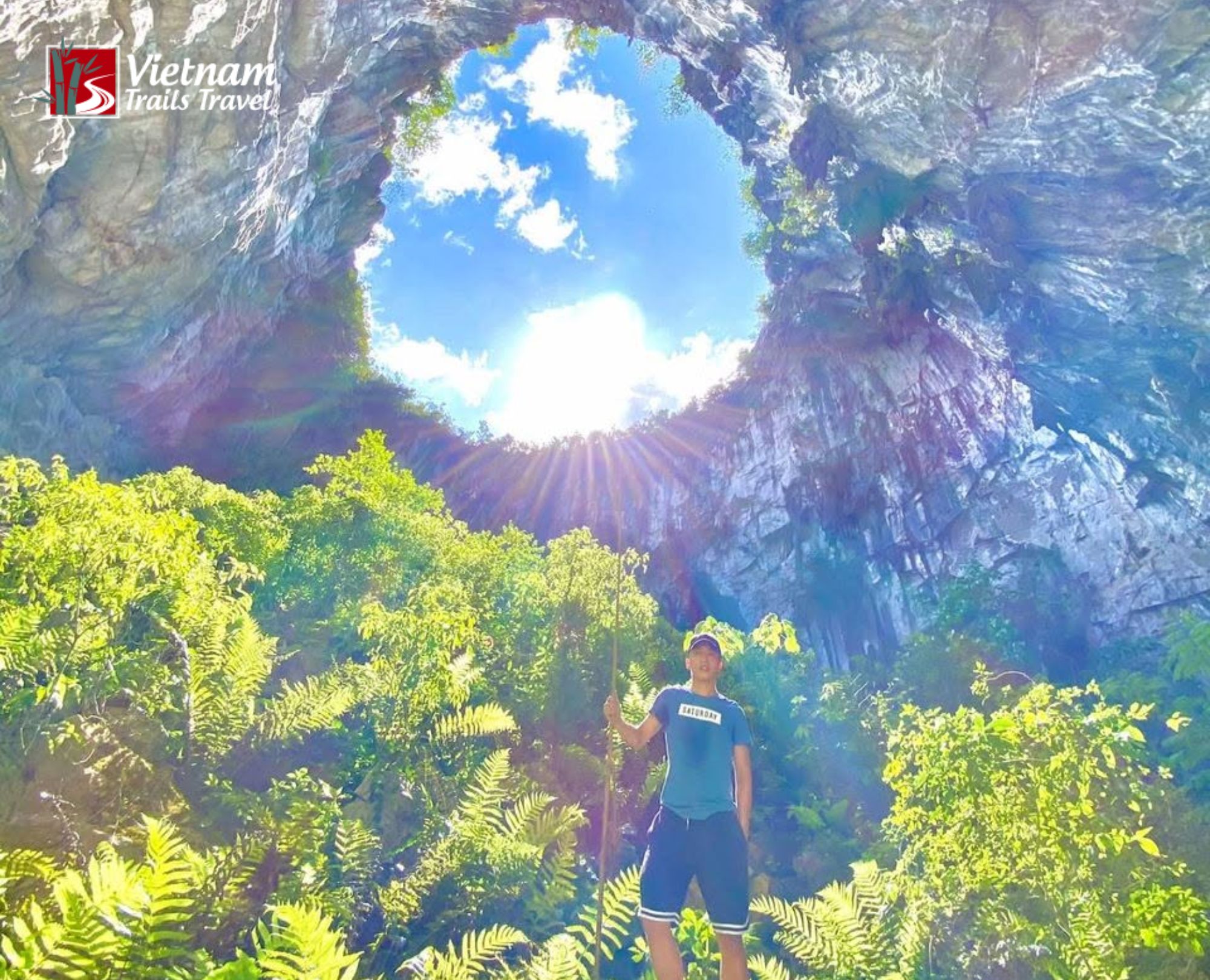
Conditions change completely at the base. Ferns cover much of the ground, and the dense growth gives the floor an almost prehistoric look. Hai said he felt tiny compared with the scale of the hole, and the sky shrank to the size of the opening above. Light reaches the floor only through that disc.
4.3 Ropes, ziplines and photos
A group led by a visitor named Minh Quang rappelled into the hole and built two ziplines across the mouth. The group used about 300 meters of static rope for the ziplines, the anchor points and the ascent and descent lines. Static rope barely stretches, which is why climbers choose it for fixed lines. The full setup took four to five hours.
Hai considers the hole a rewarding subject for photographers and believes adventurous visitors can handle it with the right equipment. A warning from Dan Tri follows: anyone attempting the descent should bring full protective gear and go with experienced people. Rope work of this scale is a specialist job, and it should not be improvised.
Read more: Ha Giang Loop Tour 3 Days 3 Nights
5. How to get there
5.1 Where the hole sits
Above Tia Chi Dua hamlet in Giang Chu Phin commune, in a remote corner of the district, a pine-covered hill carries the hole. The town of Meo Vac is the base for the visit.
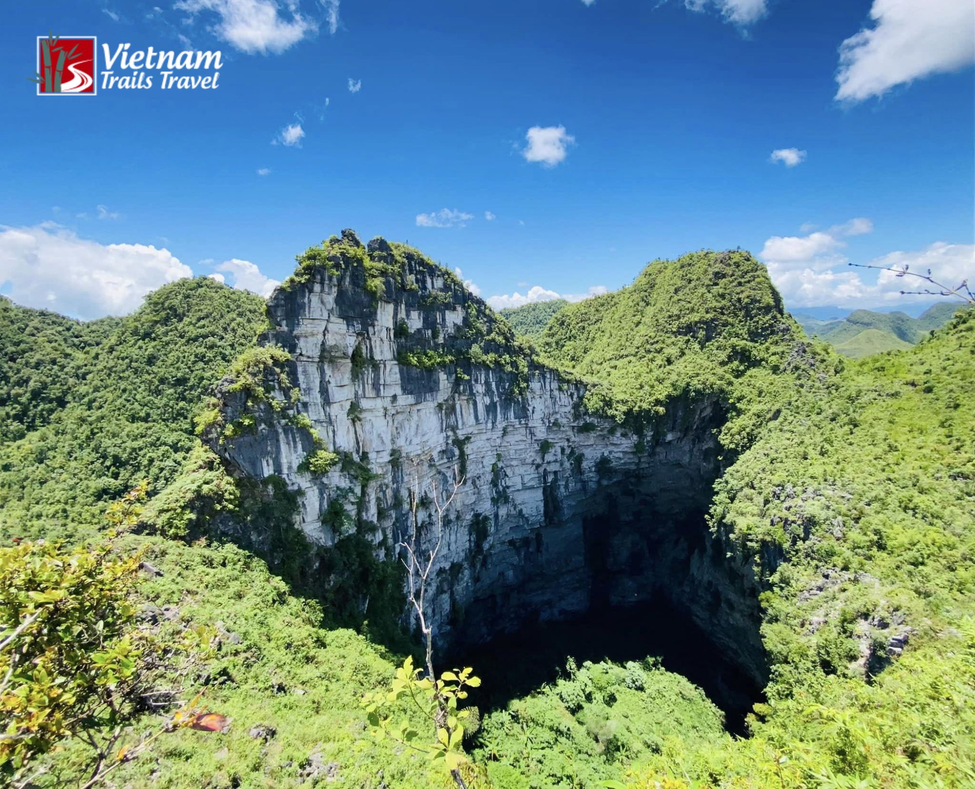
The distance from the town is 2 km on the Khau Vai road in the Dan Tri account, while other coverage says 3 km, so the true figure probably falls between the two depending on the route.
Since the 2025 administrative merger, the area is administered by Tuyen Quang, although most maps and guides still use the older name.
5.2 Distances and driving times
| Leg | Distance | Notes |
|---|---|---|
| Hanoi to Ha Giang City | About 300 km | Usual starting point of the loop |
| The city to the district town | 150 to 160 km | About 6 hours by taxi, via National Highway 4C through Quan Ba and Yen Minh |
| Ma Pi Leng Pass | About 20 km | Links the highland town to the west with the district town, crest near 1,200 m |
| District town to the hole | 2 to 3 km | Short transfer toward Khau Vai |
Buses connect the district town with neighboring towns, but they take longer and offer less flexibility. Many international visitors reach the area on a private itinerary instead.
5.3 Car or two wheels?
A car with a licensed driver suits most international visitors, mainly because the scenic highway climbs through bends for hours and the final stretch calls for knowledge of the route.
A motorbike gives more freedom to stop, yet mountain riding experience is essential on the pass. Riders without that background are better off joining a group with an experienced escort, or switching to a car for the long legs. A rider also finds it harder to carry rain gear and spare water for the whole group.
Road conditions change after heavy rain, and the short link from the town to the hill may be rougher than the main highway. The driver or the homestay host can confirm the current state on the morning of the visit.
5.4 Finding the exact pin
A name search on a map app may not drop a marker in the right spot, since the site has no ticket office or formal entrance. A pin shared by the guide or the homestay host is more reliable. An offline copy of that pin, saved before leaving town, is sensible, because mobile coverage in the mountains can drop without warning.
5.5 Fitting it into your loop
The loop can run in either direction, so the district town may fall on the first, second or third day of the trip. Visitors who want the rim visit should ask for at least half a day of slack in town, since a late arrival after a long pass crossing leaves neither time nor daylight.
A three-day, two-night itinerary leaves little room for extras, and a fourth day gives the group a margin for weather and for a slower pace at the market. Operators can often reverse the order of the stops, which helps when rain affects a section of the highway.
6. Is it safe to visit?
6.1 Can you visit right now?
Reports from 2023 describe the site as not yet developed for tourism, and the coverage reviewed for this article mentions no entrance fee and no fixed opening hours. The hole is not an easy site to visit, and conditions may have changed since then. Visitors should ask the operator or the homestay host whether any access arrangement, permit or fee applies at the time of the visit.
6.2 Why going down alone is a bad idea
Reports describe two ways down: the paths villagers use to cut grass on the slope, and rope descents on the rock face. Neither suits a casual visitor. The rock face has no trail, the drop is about 80 meters, and the climb back up takes real effort after hours of work.
Rope systems must be anchored, checked and backed up by people who do this regularly. For that reason, a descent should be treated as an expedition rather than an excursion.
6.3 Staying safe at the rim
Loose stone and soil near the edge can give way, and the risk rises after rain. Visitors should keep a clear distance from the rim, wear shoes with solid grip and stay behind the guide at all times.
Children and anyone uneasy with heights are better off viewing from a point the guide considers safe. Light fades quickly in the mountains, so a late afternoon arrival leaves little margin for the walk back.
6.4 How long rescues can take
An accident in April 2023 shows how long rescues can take in this highland. A 21-year-old man was swept into a hole about 50 meters deep near the Statue of Youth Volunteer in Pai Lung commune after a car fell about 14 meters and struck him.
Viet Nam News reported that rescuers reached him alive and brought him out after more than nine hours of work in complicated mountain terrain. That incident happened at a different hole, but it illustrates why caution near any opening in this area is not optional.
6.5 Visiting with respect
The hillside belongs to the villagers who cut grass and graze cattle there, so visitors should stay on existing paths and keep litter in a bag until town. Drone flights in Vietnam can require authorization from the authorities, and a guide can advise on the current rules before any camera goes up. Quiet behavior matters too, since the hamlet is a working farming community rather than an attraction with staff and facilities.
7. A simple day plan
The plan below assumes a base in the district town and a rim visit rather than a descent. The times are suggestions and can shift with weather and group pace.
Breakfast at 07:30 gives the group a full meal before a day that includes steep ground and little food on the hillside. By 08:30 the driver loads the car with water, rain jackets and the offline pin. On a Sunday, the central market runs in the morning, and an hour among its stalls fits neatly before the main outing.
The transfer to the hill starts at 09:30 and covers 2 to 3 km, after which the group continues on foot with the guide. Around 10:00 the rim comes into view, and the next hour is spent taking photographs from safe positions and taking a look at the hillside around it. Hai’s account suggests the opening hides its floor under trees, so patience and good light matter more than long exposure times.
Lunch follows at 12:30 in town, with time to rest before the afternoon. From 14:00, a boat ride on the Nho Que River offers a calmer second stop, and an alternative is a slow drive along Ma Pi Leng Pass for views of the canyon below. The return to the hotel by 16:30 keeps the group clear of dusk, and dinner at 18:30 closes the day.
A group with rope-trained members and a specialist team would need a separate day. The four to five hours of rigging reported for the zipline setup alone rule out any combination with other activities.
8. When to go
Seasonal flowers and harvests shape the calendar across the highlands, and they also decide how crowded the main highway becomes. January to March brings plum and peach blossom, April hosts the Khau Vai Love Market once a year, and September turns the terraced fields golden as the rice ripens. October and November bring buckwheat flowers, while December adds mustard flowers and, in a cold spell, occasional snow.
Buckwheat weekends draw the largest crowds. News reports have described congestion at Tham Ma Pass during that season, so visitors who dislike traffic may prefer a weekday departure. Winter in the northern provinces can be cold and misty, which affects visibility from the rim and the safety of wet rock.
Rain is most frequent from late spring through summer, and wet ground makes the hillside slippery. Clear autumn days are a safer choice for the rim visit, and September to December is the window suggested in the key facts table. A forecast check on the morning of the visit is worth the two minutes it takes.
Read more: Ha Giang Travel Guide: Itinerary, Weather & Loop Tips
9. What to pack
Footwear matters more than any other item. Closed shoes with deep tread handle the hillside better than sandals or smooth-soled sneakers, and ankle support helps on uneven ground. A light rain jacket fits in a small bag and covers sudden showers, while a warm layer is useful in the shade of the pines.
Water for the whole outing should be carried from town, since the hillside has no developed facilities. A power bank keeps a phone alive for the offline pin and for photographs.
Sun protection, insect repellent and a small first-aid kit round out the list. Cash in small notes is handy for snacks and for tips in the district town, where smaller shops may not accept cards.
Visitors planning any rope activity should rely on equipment provided by the specialist team and should not buy gear on the way.
10. What else to see nearby
The district offers several stops that combine well with the hole. Ma Pi Leng Pass is the legendary highlight of the highway, with a crest near 1,200 m and views of the Nho Que River far below. A boat ride on the river is among the activities most often recommended in the area, and it gives a calm contrast to the drive.
The central market in the district town runs on Sunday mornings and is widely described as the largest in the area, with highland produce, livestock and specialty dishes on sale.
Khau Vai commune lies in the same district, and its Love Market takes place once a year in April. The Tu San canyon, described in Vietnamese media as the deepest in Southeast Asia, also lies close to the pass.
Cao Bang lies to the east of the district, and the neighboring highland district with its old quarter lies to the west. A visitor with extra days can explore more of the highlands on a longer loop that includes the hole.
11. Booking with a team you can trust
A reliable operator handles the details that decide whether a mountain trip runs smoothly. The checklist is short. The vehicle should be inspected and insured, the driver should hold the right license and know the route, and the itinerary should include time buffers for weather and traffic. The guide should know the hill and be able to explain the safety limits at the rim.
Operators should also state their policy on descents in writing. A company that promises a quick rope trip to the floor without a specialist team, proper anchors and rescue planning is making a promise the terrain does not support. Clear cancellation terms and a named contact for the day of the trip complete the picture.
Vietnam Trails Travels can build a visit to the site into a private Ha Giang Loop itinerary with a licensed driver and a guide. Visitors can send preferred dates and group size to receive a tailored plan, and the team will check current access conditions before confirming the route.
12. Questions visitors often ask
12.1 Where is it?
It sits on a pine-covered hill above Tia Chi Dua hamlet in Giang Chu Phin commune, 2 to 3 km from the district town toward Khau Vai.
12.2 How deep is it?
The reported depth is about 80 meters, according to the 2022 video report. No official survey has been cited in the coverage reviewed.
12.3 Can anyone visit?
The 2023 coverage describes the site as not developed for tourism, and no fee or opening hours appear in it. Current access should be confirmed with an operator before travel.
12.4 Can beginners go down?
A descent is not suitable for beginners. The rock face has no trail, the drop is about 80 meters, and the work needs trained rope specialists.
12.5 How much time does a visit take?
Half a day is enough for a rim visit, including the short transfer from town. A rope descent with full rigging needs a separate day.
12.6 When is the best season?
Autumn and early winter offer clearer skies and drier ground. September to December is the suggested window.
12.7 Is it worth the trip?
Meo Vac Sinkhole rewards visitors who enjoy geology and who accept that the rim shows tree crowns rather than the floor. The full visual payoff belongs to those who descend with specialists, which is why most visitors treat it as one stop among several on a longer itinerary.
13. The short version
The hole near the district town was spotted in 2021 on satellite maps and drone footage, and a 2022 video put its depth at about 80 meters. Coverage from 2023 describes the site as undeveloped, with access by herders’ paths or rope descent only.
Most visitors see the rim with a driver and a guide, ideally in autumn, and they combine the stop with Ma Pi Leng Pass and the Sunday market. The Ha Giang Loop is the natural frame for the trip, and confirming current conditions with the operator before departure keeps the plan realistic.
