

Things to do in Ha Giang: Complete travel guide for first-time travelers in Vietnam
Planning a trip to Ha Giang (Vietnamese: Hà Giang) feels very different from organizing a normal trip around Vietnam (Vietnamese: Việt Nam). Roads become quieter the farther you travel into Northern Vietnam (Vietnamese: Miền Bắc Việt Nam), and the atmosphere changes quickly once the cities disappear behind the mountains.
Many travelers first arrive here because of the famous Ha Giang Loop, but the experience is often more emotional than expected.
The cold air in the mornings, long mountain roads, local markets, and slower rhythm of daily life create a side of Vietnam that feels far removed from the beaches and crowded urban tourism routes.
This Ha Giang travel guide is designed for first-time travelers researching transportation, accommodation, itinerary planning, road safety, weather conditions, and the best local experiences around Ha Giang.
Whether you want to explore Ha Giang by motorbike, join a guided tour, or simply understand how to prepare for Northern Vietnam, this travel guide focuses on practical advice alongside local insight.

Ha Giang offers changing scenery throughout the year, from green mountain valleys to seasonal flower fields, and understanding the right time to visit can completely shape your experience.
Before starting your journey to Ha Giang, it helps to understand how transportation from Hanoi (Vietnamese: Hà Nội) works, what daily travel distances actually feel like in the mountains, and why Ha Giang’s atmosphere continues to attract travelers looking for a slower and more personal side of Vietnam.
Why Ha Giang feels different from the rest of Vietnam
Ha Giang does not feel like the faster tourism routes many travelers experience in other parts of Vietnam. The atmosphere changes quickly once you enter northern Vietnam, where mountain roads replace highways and daily life moves at a much slower rhythm.
Instead of beach towns or crowded nightlife areas, Ha Giang is shaped by limestone peaks, narrow valleys, local markets, and long stretches of quiet scenery.
Part of what makes the region memorable is its rugged landscape. The mountains around the Dong Van Karst Plateau Geopark (Vietnamese: Công viên địa chất toàn cầu Cao nguyên đá Đồng Văn) create dramatic views that feel very different from the flat lowlands found elsewhere in Southeast Asia.
During colder months, fog often drifts between the limestone mountains early in the morning, changing the scenery from hour to hour.
Tourism here still feels closely connected to local life. Small villages, farming communities, and mountain roads remain part of the experience, which gives Ha Giang a more personal atmosphere compared with many larger destinations across Vietnam.
How to get to Ha Giang from Hanoi?
Most travelers begin their journey to Ha Giang from Hanoi, usually by overnight sleeper bus, limousine van, or private transport. The distance between Hanoi and the city of Ha Giang takes around 6hrs by 292 km on the mountain road, depending on weather, traffic, and road conditions in northern Vietnam.
Overnight travel remains the most common option because many buses leave Hanoi in the evening and arrive early the next morning.
Sleeper buses and limousine vans from Hanoi
Taking a bus from Hanoi is the most practical choice for first-time travelers planning to travel to Ha Giang. Sleeper buses are cheaper and widely available every night, while limousine vans usually provide more personal space and smoother rides.
Some travelers prefer limousine services because the roads approaching Ha Giang from Hanoi can feel long during rainy weather or holiday traffic periods.

Private car options for mountain travel
A private car is more comfortable for travelers wanting a slower journey to Ha Giang, especially for families or small groups exploring northern Vietnam. This option also gives more flexibility for photography stops and mountain viewpoints along the route.
Should you rent a motorbike in Ha Giang city?
Many travelers rent a motorbike after arriving in Ha Giang city (Vietnamese: Thành phố Hà Giang) instead of driving directly from Hanoi. This is usually safer because mountain roads around Ha Giang include steep curves, foggy sections, and narrow passes that can feel challenging for beginners.
Ha Giang Loop itinerary for first-time travelers
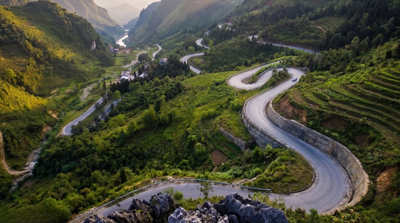
The Ha Giang Loop is usually the main reason many travelers plan a trip to Ha Giang. Most first-time travelers follow a 3-day itinerary that combines mountain roads, local towns, river viewpoints, and some of the most scenic landscapes in northern Vietnam. While distances on the map may appear short, the journey often takes longer because roads curve through mountain passes and cliffside sections.
Day 1: Quan Ba and Yen Minh
The first day of the Ha Giang Loop normally starts from Ha Giang city before heading toward Quan Ba (Vietnamese: Quản Bạ) and Yen Minh (Vietnamese: Yên Minh). This part of the route introduces travelers to the changing scenery of the region, including mountain valleys, winding roads, and limestone landscapes. Many people stop frequently for photography because the scenery changes quickly throughout the day.
Day 2: Dong Van and Ma Pi Leng Pass
The road toward Dong Van is often considered the highlight of the itinerary. This section crosses parts of the Dong Van Karst Plateau Geopark, where limestone peaks rise sharply beside narrow roads. The route through Ma Pi Leng Pass (Vietnamese: Đèo Mã Pì Lèng) follows steep cliff edges and remains one of the most scenic mountain pass experiences in Vietnam.
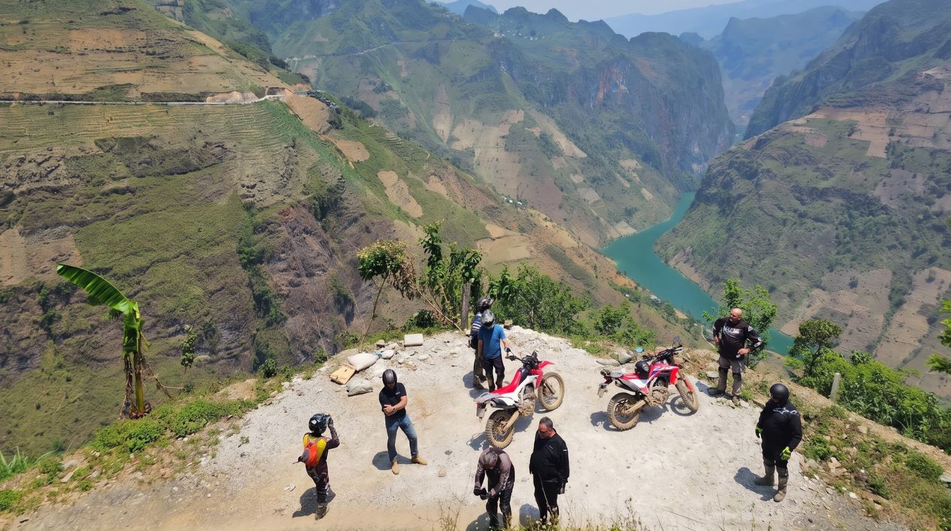
Day 3: Meo Vac and the Nho Que River
On the final day, many travelers continue toward Meo Vac (Vietnamese: Mèo Vạc) and nearby viewpoints above the Nho Que River (Vietnamese: Sông Nho Quế). Boat rides on the river have become a popular attraction during the Ha Giang Loop journey because the canyon scenery feels completely different from the higher mountain roads above.
Easy rider tours or self-driving?
For beginners, guided tour options with easy riders are usually safer than self-driving a motorbike. Mountain roads around Ha Giang can become slippery during rainy weather, and fog sometimes reduces visibility on higher passes early in the morning. Many first-time travelers choose Ha Giang Loop tours because local drivers already understand the road conditions and mountain routes well.
The most memorable places around Ha Giang
Beyond the mountain roads themselves, Ha Giang is filled with small towns, valleys, and viewpoints that shape the atmosphere of the region. Some places are known for dramatic scenery, while others feel memorable because daily life still moves slowly through local markets, farming villages, and narrow streets.
For many travelers, the most interesting part of the journey is not only the landscape, but how different each stop feels from the previous one.
Dong Van old quarter and Sa Phin
Dong Van (Vietnamese: Đồng Văn) remains one of the most recognizable towns in the region, especially for its old quarter surrounded by rocky mountain scenery. During the evenings, the atmosphere becomes quieter as travelers gather in small cafés and traditional Vietnamese restaurants near the center.
Not far from Dong Van, the area around Sa Phin (Vietnamese: Sà Phìn) reflects another side of local history connected to old Hmong architecture and mountain communities.
Ma Pi Leng Pass and the Nho Que River
The road through Ma Pi Leng Pass is often considered the most scenic section of the Ha Giang Loop. Sharp cliff edges overlook the green waters of the Nho Que River far below, especially on clear mornings when visibility across the valleys improves.
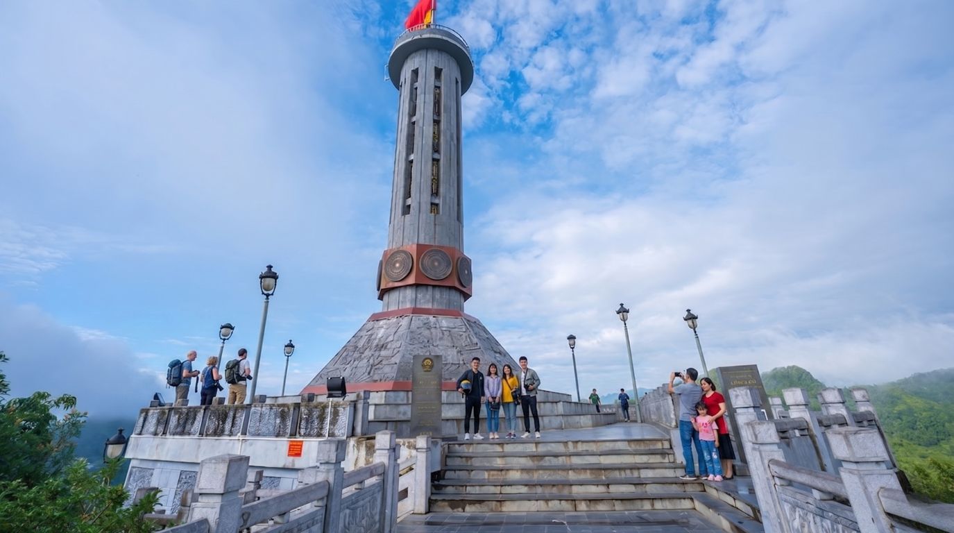
Lung Cu Flag Tower near Vietnam’s northernmost point
Lung Cu Flag Tower (Vietnamese: Cột cờ Lũng Cú) stands close to the northernmost point of Vietnam near the border region. Many travelers visit Lung Cu not only for the viewpoint itself, but also for the quieter roads and smaller villages surrounding the area.
Hoang Su Phi and rice terraced landscapes
Compared with the rocky mountain scenery around Dong Van, Hoang Su Phi (Vietnamese: Hoàng Su Phì) is better known for layered rice terraces and large terraced fields stretching across the hillsides. During harvest months, the rice fields change color quickly depending on sunlight and weather, creating one of the most recognizable agricultural landscapes in northern Vietnam.
Best time to visit Ha Giang in 2026
The best time to visit Ha Giang depends on the type of scenery and weather you want to experience. Because the region sits in northern Vietnam, conditions change noticeably throughout the year, especially in the mountains. Many travelers prefer autumn and early winter when the roads are drier and visibility across the valleys improves.
Buckwheat flower season in October and November
October and November are popular because buckwheat flower fields begin appearing across parts of Ha Giang. During this season, the mountain scenery changes color as pink and purple flowers spread through valleys near local villages and higher roads around the Loop.
Rice terrace season and green mountain valleys
Late summer and early autumn are also good months to visit if you want to see rice terraces and green rice fields across the mountain landscape. Areas around the hills become especially colorful before harvest season begins.
Winter fog and cold weather in Northern Vietnam
Winter months between December and February can feel very cold in northern Vietnam, especially early in the morning. Ha Giang weather conditions during this period often include fog along scenic mountain roads, which can reduce visibility around higher passes.
Where to stay in Ha Giang, Dong Van and Meo Vac?
Choosing the right accommodation in Ha Giang depends on your travel style and how many days you plan to spend around Ha Giang. Some travelers prefer staying in local mountain villages, while others choose hotels in town centers for easier transportation and food options during the Ha Giang Loop.
Homestays in mountain villages
Homestays remain one of the most popular accommodation choices for travelers wanting a quieter experience in minority villages. Many homestays are built close to rice fields, mountain valleys, or traditional local houses, giving travelers a better sense of daily life in the region. Conditions can feel basic in remote areas, but the atmosphere is often more personal than standard hotels.
Hotels and guesthouses in Ha Giang city
Most people spend their first night in Ha Giang City before starting the Loop. The city of Ha Giang has a wider range of accommodation options, including budget guesthouses, modern hotels, and hostels for backpackers. Staying here also makes it easier to organize motorbike rentals, guided tours, or transportation for the following morning.
Where to stay along the Ha Giang Loop
For travelers following the Ha Giang Loop, the most common overnight stops are Dong Van and Meo Vac. Both towns have growing accommodation options ranging from local homestays to small mountain hotels near the main roads.
Common mistakes first-time travelers make
One of the biggest mistakes people make when planning a trip to Ha Giang is underestimating travel time in the mountains. Distances on Google Maps may look short, but weather, fog, and winding roads often slow the journey more than expected. Some travelers also try to complete the Loop too quickly, which can make the travel experience feel tiring instead of enjoyable.
Another common issue during Ha Giang travel is arriving without warm clothing, especially between November and February when temperatures drop early in the morning. Travelers planning to visit Ha Giang for only one or two days also sometimes realize too late that the region deserves a slower schedule.
Spending extra time in smaller towns and mountain villages usually creates a better experience than rushing between viewpoints. For beginners, renting a motorbike without previous mountain riding experience can also become stressful on steep roads and sharp turns. Many first-time travelers eventually decide that easy riders or guided tours are more comfortable for longer routes around the Loop.